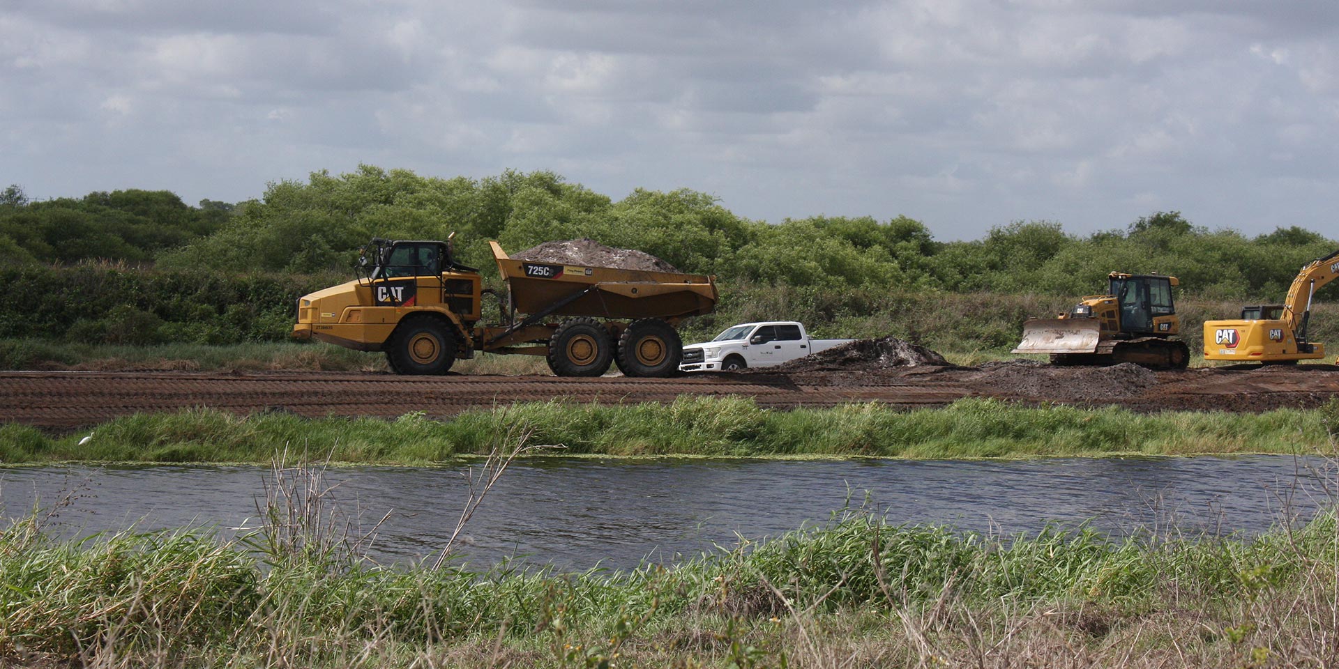
Florida’s Everglades region is much more than half-submerged stumps, Cypress trees draped in Spanish moss, and alligator-infested waters — images that generally come to mind at its mention. In reality, it is a complex ecosystem that plays an integral role in naturally treating water affected by agricultural runoff, continued residential development and industrial impact as it journeys southward through the state. One of the largest projects being developed for the South Florida Water Management District to help ensure the region can continue to provide that critical function is the C-139 Flood Equalization Basin (FEB), near Clewiston, Florida. When complete, this 11,000-acre storage feature will both store water and control its release to an adjacent stormwater treatment area, thereby ensuring quality and minimizing adverse impact to the area. Working as a subcontractor to a Candotte-Ryan Joint Venture, Westwind Contracting has been tasked with building up 8.6 miles of existing river slopes to allow for increased volume and flow during peak seasonal periods. The job, which would generally be rife with grade stakes to ensure slopes are uniform and to plan, is instead being completed using dozers equipped with GNSS-based machine control. Doing so, has allowed Westwind to see an impressive uptick in productivity, better allocation of manpower on site and a finished product that will improve the ecosystem for decades to come.


- image 1
- image 2
- image 3
- image 4
Moving Mountains
Though they’ve done a good deal of levee restructuring and modifications in the past (the aforementioned Merritt Island work is a good example), the C-139 project took those skills to a whole new level. The scope of work alone was impressive, according to Justin Lacayo, the company’s GPS specialist.
“Because the banks being built up demanded so much soil and the structure itself was so lengthy, the amount of earth brought in was impressive — something in the range of 400,000 cubic yards,” he said. “In fact, there was once literally a small mountain of soil that had been stockpiled near the site entrance for years in anticipation of this project — we went through all that and still had to import additional material.”
To better illustrate the project’s size and demands, Westwind had a fleet of about a dozen 19 cu. yd. articulated haul trucks continuously bringing in loads for use in building up the riverbanks. When needed, Lacayo can sometimes be found operating one of those trucks.
“I started here at Westwind as a general laborer, a water truck driver, actually,” he said. “Then, thanks to the confidence that Ozzie Romero, our superintendent, showed in me, I started assisting the surveyors, which gave me a general idea for elevations and how the survey side of things works. I picked up on it quickly, but that also speaks to the user-friendliness of the Topcon systems we use — everything from the base and rovers to the machine control systems is very intuitive.”
“Because the banks being built up demanded so much soil and the structure itself was so lengthy, the amount of earth brought in was impressive — something in the range of 400,000 cubic yards.”
— Justin Lacayo, the company’s GPS specialist

A Big Buildup
To raise each levee bank by the requisite six feet, Westwind relied largely upon a pair of Cat D5 dozers, each equipped with the Topcon MC-Max Dozer system. According to Lacayo, the project, while simplistic in design, also offered its share of challenges — all of which were fully met by the new machine control solution.
“First, the easy part,” he said. “Long projects like this are actually very good for getting an operator into GPS for the first time. At its most basic, you have one stop here and one stop there, so it's easy for them to just push a lift to get comfortable with it. In fact, we have an operator who learned how to run GPS on this job and he's now pushing lifts in one area while he's doing finished grade in another. We are also helped by the fact that, by nature of the new system in the dozer, we are picking up more satellites. Where the old system only picked up a couple of satellite constellations, we are now getting as many as five or six.”
That coverage is important to address the part of the project that is not so simplistic: the slopes themselves. With a distance of more than four miles in each direction and two slopes per side of the river, that represents 16+ miles of slopes, which Lacayo said could not realistically be done using conventional survey methods.
“Every contractor on this site is running GPS,” he said. “A company without it would not be able to maintain the production levels everyone else is bringing. Others would be forced to wait while that company completed a section or pounded yet another stake in the ground. So that’s not even an option. Couple that with the fact that we’ve been hindered by very rainy conditions which have pushed us back a bit and the case for GPS-based machine control is made. I can’t imagine how far behind we’d be without the production we get with MC-Max dozers.”
DIY Positives
Support for all of Westwind’s GNSS-based solutions is through Lengemann Corporation, the regional Topcon dealer, which, according to Lacayo, has been outstanding in meeting their needs.
“We haven’t had any issues with the systems but anytime we’ve had a GPS-related concern, they had it resolved within a day or so,” he said. “Even though I've only been doing this for about a year, I’ve become very self-sufficient, largely because of Lengemann’s help. They've shown me how to do software installs in our excavator and they're currently showing me how to the same in our dozers.”
He said that, while some equipment dealers might hesitate to show customers such practices — seeing it as taking away their work — Lengemann is not one of those.
“I think they view it as just another opportunity to just make their customer better — and I like that.”
“We haven’t had any issues with the systems but anytime we’ve had a GPS-related concern, they had it resolved within a day or so.”
— Justin Lacayo, the company’s GPS specialist
Added Benefits
Though the work they are doing in Clewiston is in a wide-open area without any blockages to satellite access, Lacayo said it’s reassuring to know that the MC-Max Dozer solution has designed in contingencies for times when such is not the case.
“We’ve been on jobsites where access to the sky has been limited and we needed to resort to a total station for LPS,” he said. “With this solution, switching modes in order to do so is fast and simple. And even though we didn’t use it on this project, the Slope Lock feature that is a part of the dozer’s machine control system has been a huge plus for us in the past. For example, we recently completed a levee restoration job on Merritt Island in which a decision was made late in the game that the top of the structure, which was designed flat, should instead be sloped. Since that wasn’t in the design, we locked in the slope at 2%, cut the top of the levee off with that 2% and the customer was pleased with the results. More importantly, it was done without any loss of time, so the project stayed on schedule and in budget.”

Recipe for Success
Florida is slated to receive roughly $19 billion of the $1.2 trillion Bipartisan Infrastructure Bill recently signed into law. That influx of dollars has resulted in a huge number of projects — work that had been in economic limbo — to finally kick off.
“There’s a lot of money being poured into the south Florida infrastructure,” said Polizzi. “We have roughly a dozen and a half projects ongoing right now, jobs that extend all the way down to the Florida Keys. Like everyone else in this industry, we are challenged to find good, quality workers to keep pace with the growth. But that’s just another area in which the GPS and machine control solutions have played a key role: we can definitely do more now with less — and do it better. We’re seeing that out at C-139 and, to me, that’s what will keep us competitive moving forward.”